The quick numbers
| Price, cap, EV | $0.066 (20 Aug), about A$21.8M, EV about A$15M |
| Shares | ~330.9M, another 526,316 waiting on the Q3 GM |
| Last raise | A$6.0M at 9.5c, May 26. PLS took its share to hold 5.1%. Price now 30% under the raise |
| Cash | A$6.56M at 30 June. The company's own 5B prints 4.60 quarters at pre drilling burn. My number is $3.5 to 4.5M left by end of September with two rigs going |
| Options | 74.23M unlisted. Only the 24.4M at 7.5c are close, rest struck 14.875c to 60c. Fully diluted ~405M |
| Free float | About 66% outside the top 20. Top 20 hold 34% including PLS 5.1% and board around 3% |
| The event | Mandacaru assays. Window mid September to mid October on my numbers |
Why it's on the screen
Flushed 20% on 6.35x volume on 10 Aug into no news. ASX asked, company answered that it knew nothing. Resource specialist desks bought about $1M over four sessions while retail sold into it. Price sits 30% under the placement that funded the drills now turning. That pattern is the reason it's here. The machine's own record of the name is on the track record, tagged and pulled out of the tallies while I'm covering it.
The lithium story
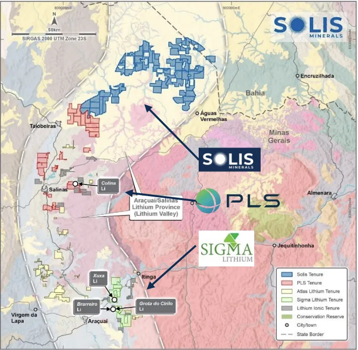
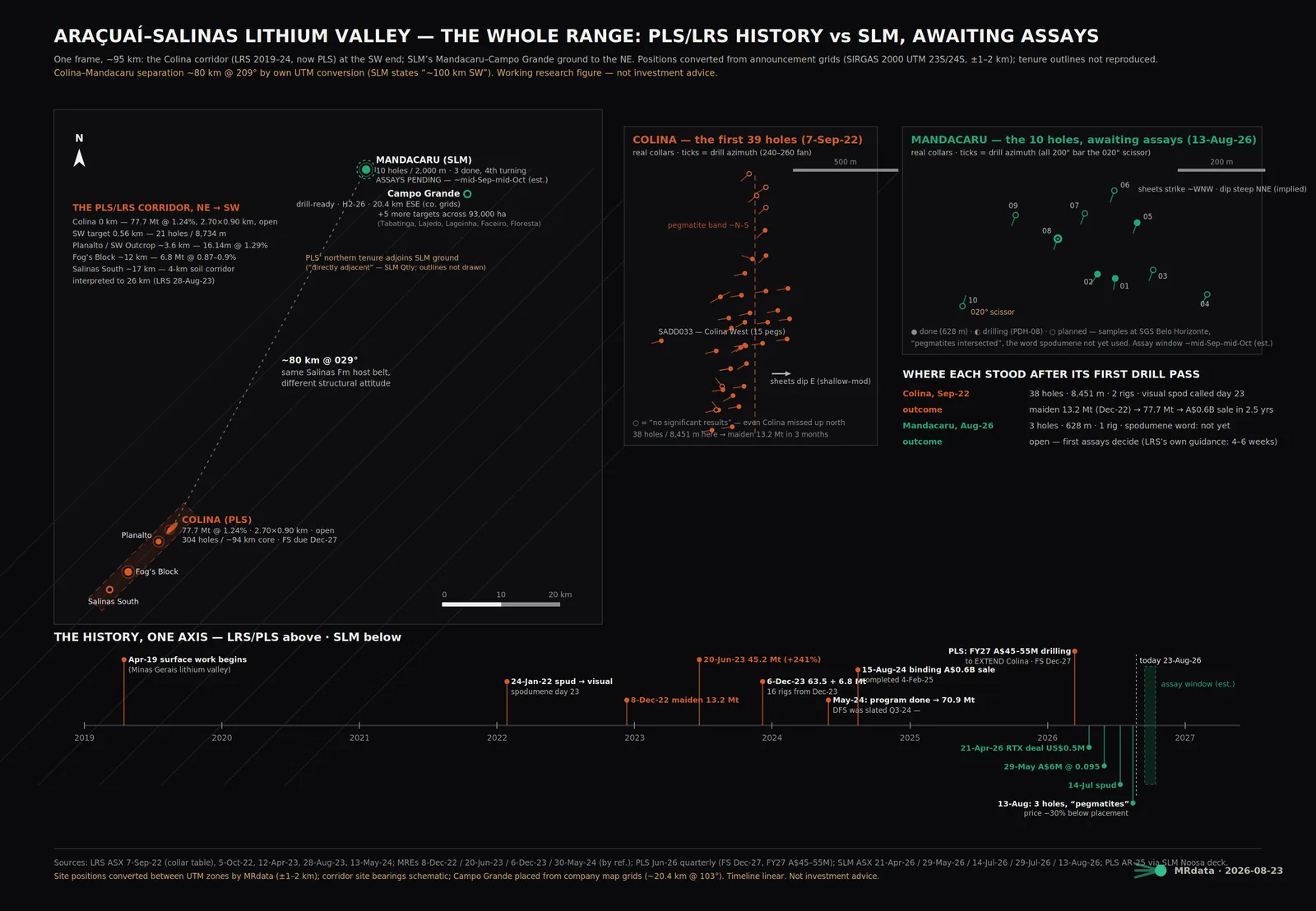
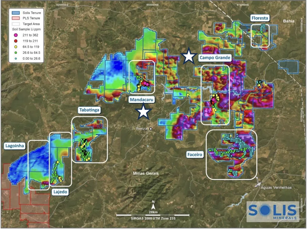
93,000 hectares in the Aracuai Salinas lithium valley, bought off Rio Tinto for US$0.5M plus a 1.75% royalty, run by the crew that found Colina. PLS now holds Colina at 77.7Mt @ 1.24% inside the $0.6B Latin Resources takeover. Same host rocks, Salinas Formation schists with S type granites as the source. Not next door though. Colina is about 80km away to the SSW, and the PLS boundary only touches the SW corner of the package, 35 to 40km from Mandacaru. Adjacent is true for the tenure, a stretch for the flagship.
Mandacaru
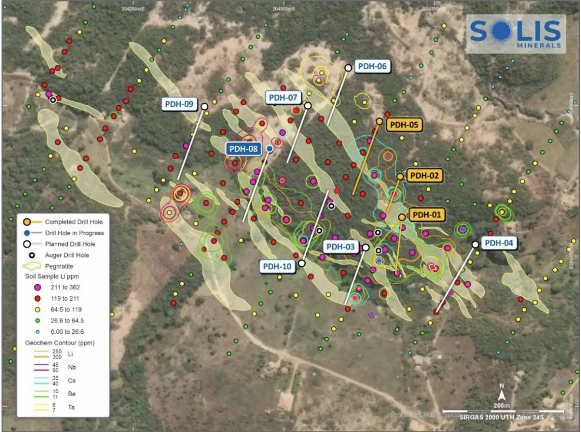
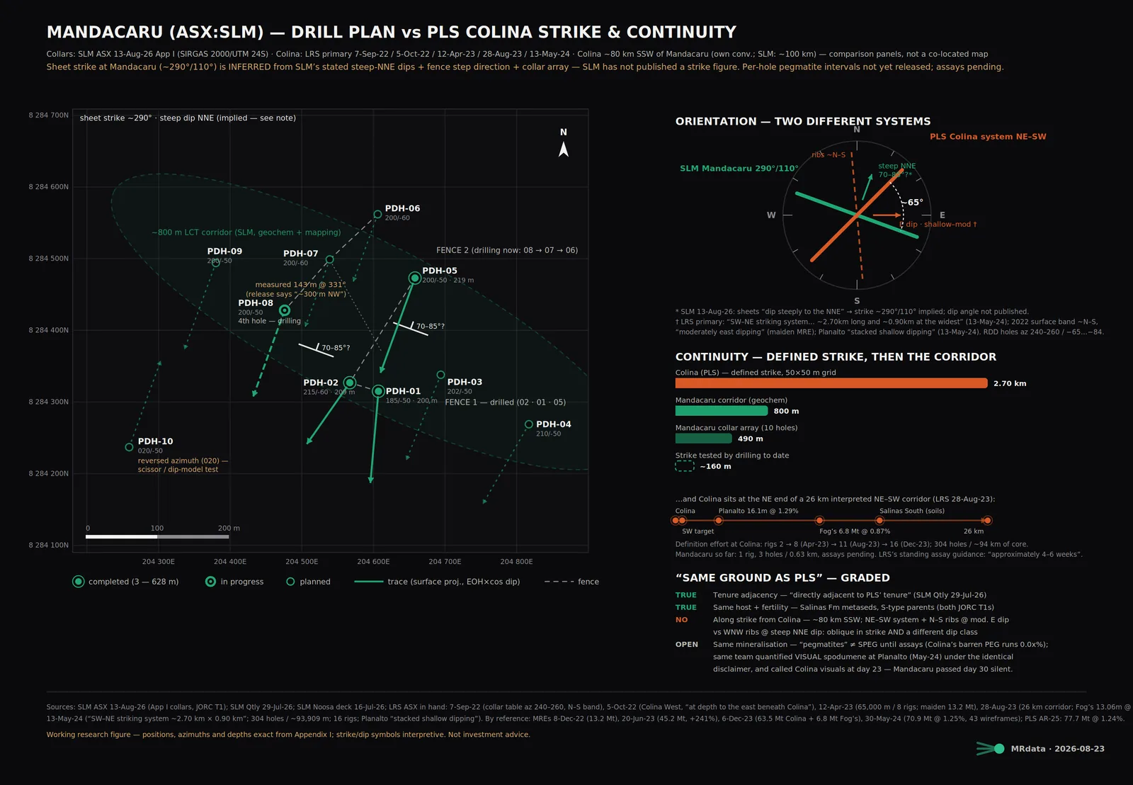
Ten holes, 2,000m, spudded 14 July. Three done (200m, 208.9m, 219m), fourth turning. Pegmatites hit from 30 to 40m below surface, right where the mapping said they'd be. The sheets dip steep NNE, which puts strike roughly WNW. That is not the Colina direction, worth knowing before anyone sells you strike continuity. Hole 10 is the interesting one, drilled backwards at 020 to test the dip call itself.
The drilling on the mags
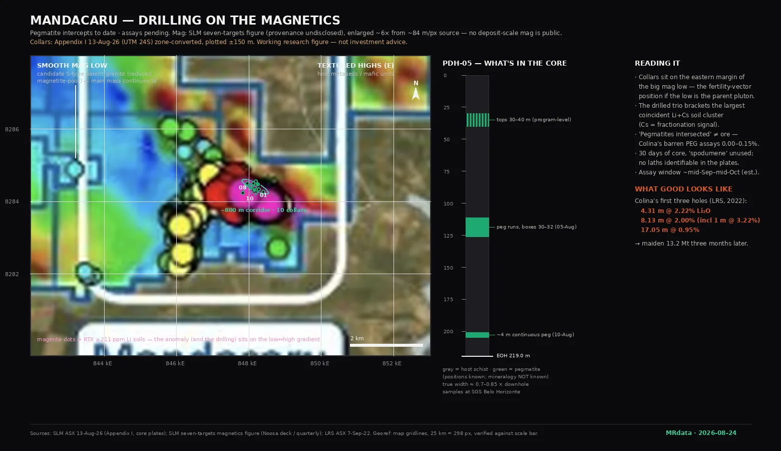
The collars sit on the eastern edge of a big smooth magnetic low. A smooth low in this setting usually means the S type granite, the parent body the pegmatites shed from. The soil anomaly and the drilling both sit right on the gradient between the low and the textured high ground east of it. That's the textbook position if the low is the fertile pluton. Caveats stated plainly: the only public mag is the company's district picture at about 84m a pixel, nobody has ever announced who flew it, Rio's data package had no geophysics in it, and drone mag was still "planned" back in April. My collar overlay is good to about 150m.
The core
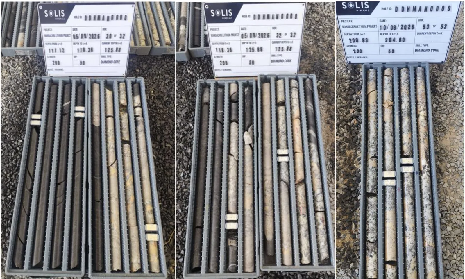
The plates give away more than the announcement did. Azimuth and dip on the boards match hole 5. It was at 125.9m on 5 Aug and 204.6m on 10 Aug, about 16m a day. Multi metre runs of pale pegmatite through 111 to 126m and a 4m run around 200 to 205m, so the stacked sheet model is real all the way down the hole. What's missing is the word. Thirty days of core and spodumene hasn't been used once, no laths visible in the boxes they chose to show, and this same team was still calling visual spodumene at Planalto in May 24 under the identical disclaimer. Read that silence however you like.
The bull case runs through weathering and it's worth spelling out. Surface rock chips here only run 359ppm Li2O, which is pathfinder level, thirty times under ore grade. In this climate spodumene rots to clay near surface and the lithium leaches out, so the surface only ever shows the washed out shadow of what's underneath. Same logic held at Colina. That argument is required for the thesis to work, and it cannot be tested from surface. Assays decide.
What good looks like
Colina next door is the calibration for the day SLM's numbers land. First three holes ever: 4.31m @ 2.22, 8.13m @ 2.00 incl 1m @ 3.22, 17.05m @ 0.95. The build out: 26.88m @ 1.40, 28.80m @ 1.16, 33.07m @ 1.83, 27.15m @ 1.45. The tail: 8.45m @ 3.57 incl 4.17m @ 5.79. And the misses, because fertile systems still miss: their north fence holes 007 to 010 came back with no significant results.
The effort behind those numbers keeps the comparison honest. Colina took 304 holes, about 94km of core and 16 rigs on a 50x50 grid, spud to $0.6B sale in two and a half years. Mandacaru is 1 rig, 3 holes, 0.63km of core. One more thing before comparing intercepts: Colina's holes cut its flat lying sheets at close to true width, Mandacaru's steep sheets mean you knock 15 to 30% off any downhole number first.
Campo Grande
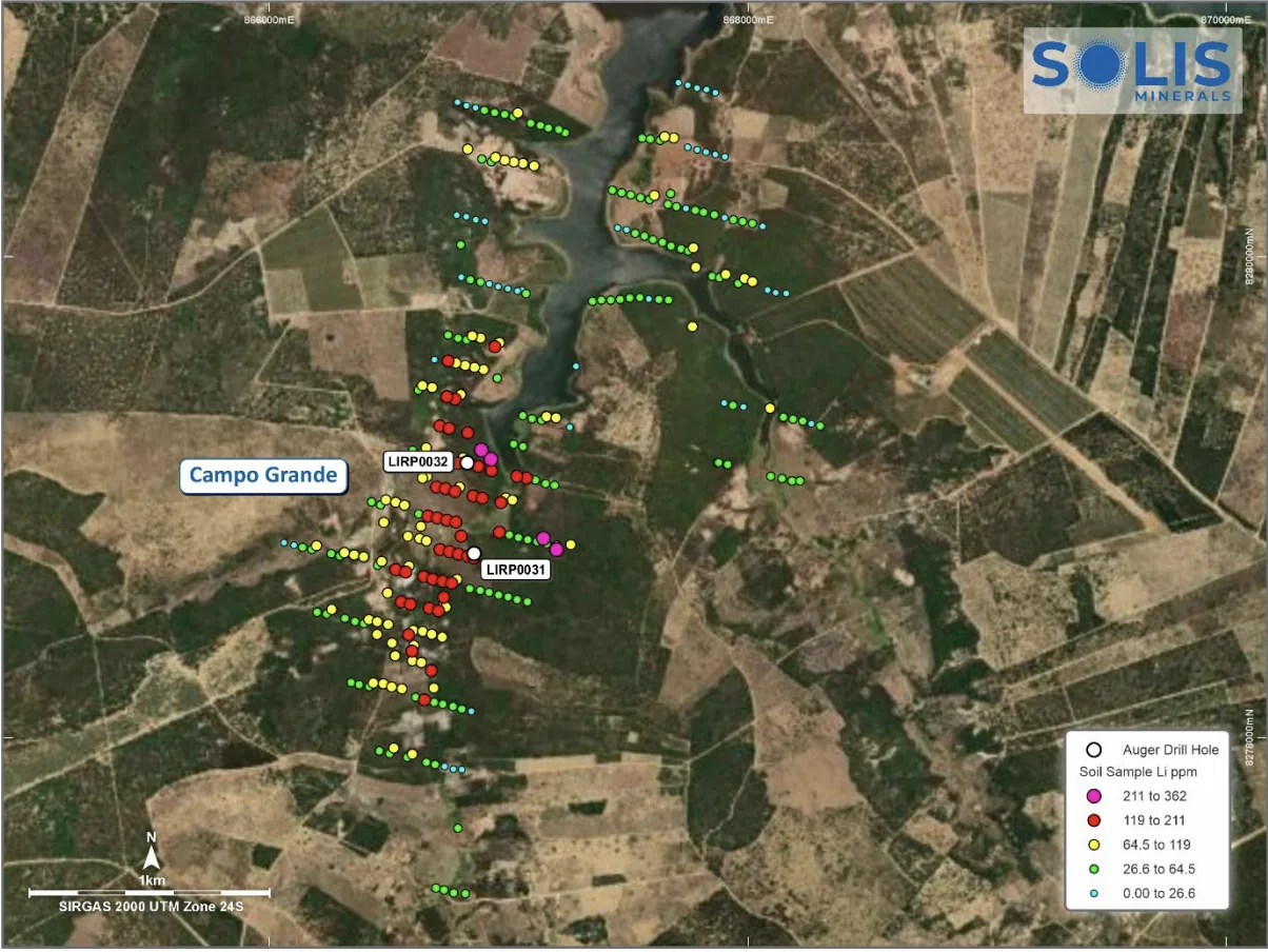
Second target, drills H2. 20.4km ESE of Mandacaru on the company's own map grids, they say 18. Longer anomaly than Mandacaru but weaker, mostly the 119 to 211ppm class. Funny detail: this is the target the company calls Colina aligned, and its trend really is closer to Colina's rib direction than anything at Mandacaru. If Mandacaru disappoints, this is the fallback with the same weathering logic and no core yet.
Where the thesis sits
Proven: the system continues underground. Tops 30 to 40m below surface, pegmatite runs to 155m vertical, and the sheets barely outcrop at all, so what you see at surface is float and shadow. Proven: the chemistry is the fertile family, lithium with caesium, tantalum, niobium and beryllium all together, sitting on the margin of the mag low. The estimate, and I label it as one: spodumene in fresh rock under the weathering front. The unknown, which is the entire bet: grade and width against the Colina benchmark.
Falsifiers I'm tracking, dated the day they trip: a raise before assays, resource desk buying reversing for a week, weak assays, a burn blowout in the September 5B, a volume break under the 10 Aug low.
Copper on the side
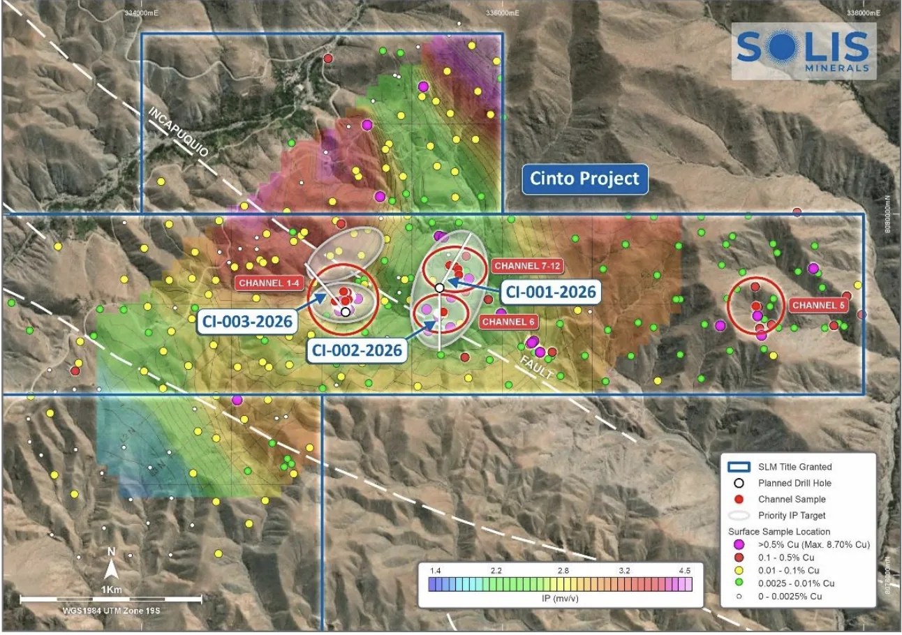
Cinto in Peru spudded August, 13km from Toquepala. First three holes test the channel sample zones (best 23.4m @ 0.88% Cu, best surface chip 8.70%) over moderate IP. Two things to hold onto when the news flow starts: the published chargeability scale tops out at 4.5 mv/v which is modest for porphyry hunting, and the biggest IP targets are still untested. Cucho behind it: 2014 drilling hit in every hole, 91.2m @ 0.33% Cu from surface, permits now in hand. Copper fills the tape while the lithium cooks.
The clock
Mid September to mid October, assays, the event. Around then Cinto's first core news and maybe a geophysics announcement out of Brazil. Late October the program wraps and the September quarterly shows the real burn. Q3 GM for the director placement shares. Campo Grande spuds H2. And PLS quarterlies keep printing next door, $45 to 55M of drilling this year aimed at extending Colina, free strike updates every quarter.
Maps and overlays my own workup from the releases.